H
E A V Y R A I N A N D
F L A S H F L O O D S
 Floods
are the deadliest natural disasters, killing more people in the United States
per year than tornadoes, hurricanes, windstorms or lightning. In recent years,
on average more than one hundred people per year have died in the U.S. during
floods, especially flash floods. Sixty percent of those killed died trapped
in vehicles or while trying to escape from automobiles stalled in rising water.
As little as two feet of water can float a car or truck, possible sweeping it
to deeper water or overturning it. Water moving at 4 miles per hour, a brisk
walking pace, pushes on anything in its path with a force of 66 pounds per square
foot. At double that speed the force increases dramatically to 264 pounds per
square foot.
Floods
happen when water breaks free of its banks or boundaries and drenches land that
is usually dry. Because seventy-five percent of the Earth is covered by water
in the form of oceans, lakes, rivers, streams, rainforests, swamps, glaciers,
and springs, floods are common and expected occurrences. But throughout history,
humans have chosen to live near bodies of water for their considerable benefits:
the fertile soil left when the waters recede, easy access to shipping and trade,
fishing, cooking, bathing, washing clothes, plentiful drinking water, and the
aesthetic value of the waters. But there are drawbacks to living by a river
or lake or ocean: the land onto which their waters spill is called a floodplain,
and people who live on floodplains must, as the name implies, be prepared for
the eventuality of a flood. Even when dams, dikes, and seawalls have been built
to reduce the severity of a flood, the water contained in one place often floods
the land upstream or downstream. When floods descend on populated areas that
are insufficiently prepared, they become natural disasters. The severity and
lethality of floods in such places is dependent on weather, the ground’s
ability to soak up moisture, and the people and buildings in the area of the
floodplain.
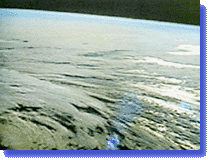
 Floods
originate in the atmosphere, where the unequal heating of Earth’s surface
by the Sun causes air and moisture to circulate. Though the quantity of water
on the planet remains constant, the amount of water in any given location is
always in flux due to this process, called the water cycle. (See Marshall Shepherd’s
presentation of the water cycle in Live From The Storm program
1, and Activity 1.3 in the Teacher’s Guide.) The Sun heats water until
the liquid becomes a gas, water vapor. This vapor then mixes with tiny salt,
soil and smoke particles and, when the temperature cools, condenses on the particles
into liquid water drops, which, in turn, create a cloud. (See Activity 2.1 in
the Teacher’s Guide, Creating
Clouds.) In the daily course of the water cycle, 4,200 billion gallons of
water (out of the 40,000 billion gallons which exist in the Earth’s atmosphere)
fall to the ground as precipitation, 2,800 billion gallons evaporate into the
air, and 1,400 gallons soak into the ground or run back into bodies of water,
continuing the cycle.
Floods
originate in the atmosphere, where the unequal heating of Earth’s surface
by the Sun causes air and moisture to circulate. Though the quantity of water
on the planet remains constant, the amount of water in any given location is
always in flux due to this process, called the water cycle. (See Marshall Shepherd’s
presentation of the water cycle in Live From The Storm program
1, and Activity 1.3 in the Teacher’s Guide.) The Sun heats water until
the liquid becomes a gas, water vapor. This vapor then mixes with tiny salt,
soil and smoke particles and, when the temperature cools, condenses on the particles
into liquid water drops, which, in turn, create a cloud. (See Activity 2.1 in
the Teacher’s Guide, Creating
Clouds.) In the daily course of the water cycle, 4,200 billion gallons of
water (out of the 40,000 billion gallons which exist in the Earth’s atmosphere)
fall to the ground as precipitation, 2,800 billion gallons evaporate into the
air, and 1,400 gallons soak into the ground or run back into bodies of water,
continuing the cycle.
Particularly
heavy rains can result in abnormally high water levels; heavy snowfall can cause
damage in the spring when rising temperatures cause snowmelt. The ground in
a particular area may become saturated, causing unabsorbed water to pool, when
a warm or cold front stalls over it, dumping a large amount of precipitation,
or when a quickly moving storm keeps passing over the same area in a phenomenon
called "training," drenching the land below.
Saturation—and
flooding—is also dependent on the ground’s ability to accept copious
amounts of moisture. Precipitation sinks into the ground into plant roots and
through layers of soil and porous rock, filling underground holes until this
groundwater hits solid rock and can’t sink any further. The soil and roots
become saturated until they can’t absorb any more moisture, and so the
underground water table moves the only way it can, up, to the surface where
it forms puddles and other bodies of water. In places where there is a thick
layer of soil and porous rock between the surface and the solid rock, more moisture
can be absorbed. The opposite is true for rocky areas like mountains or canyons
where there is little to no soil. When no more water can be absorbed, the excess
runs off into oceans and other bodies of water, and their water levels increase.
Soil
that is parched and hardened can accept less moisture than soil that is already
wet, and dryness of the Earth is a factor in flash floods in the Western U.S.–a
seemingly small amount of precipitation can trigger a flood if it is not absorbed
quickly. Floods usually occur in the Eastern U.S., on the other hand, because
of the huge amounts of precipitation which saturate the moist ground until the
soil can hold no more water. The Great Flood of 1997 was occasioned by the melting
of the 100 inches of snow dumped by 8 blizzards in the area around Grand Forks,
North Dakota, during the previous winter.
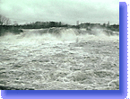
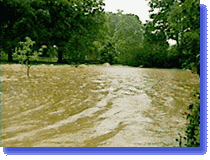 River
floods often build gradually and can be measured by scientists, who pay attention
to rain and snowfall and calculate the rising water levels and ground saturation
to make a prediction about when and if a river will overflow its banks. If a
season has been especially rainy or snowy, conditions are ripe for this largest
and most severe type of flood. Being able to predict what will happen means
that people are usually prepared, but river floods are still extremely dangerous
because the power of the water builds as the water levels rise. Pressure builds,
especially at the bottom of the river, and as the water rushes along the riverbed,
whirlpools may form. The river can act like a cannon, spitting out tree trunks
and other objects at high speeds. The raging water carries with it the debris
it has collected along the way: uprooted trees, mud, rocks, even human refuse
like old car parts or machinery.
River
floods often build gradually and can be measured by scientists, who pay attention
to rain and snowfall and calculate the rising water levels and ground saturation
to make a prediction about when and if a river will overflow its banks. If a
season has been especially rainy or snowy, conditions are ripe for this largest
and most severe type of flood. Being able to predict what will happen means
that people are usually prepared, but river floods are still extremely dangerous
because the power of the water builds as the water levels rise. Pressure builds,
especially at the bottom of the river, and as the water rushes along the riverbed,
whirlpools may form. The river can act like a cannon, spitting out tree trunks
and other objects at high speeds. The raging water carries with it the debris
it has collected along the way: uprooted trees, mud, rocks, even human refuse
like old car parts or machinery.
Depending
on the severity of the flood, the polluted river will cover enormous tracts
of land before its pent-up energy is expended, dragging along whatever gets
in its way. During the Great Flood of 1927, the enormous Mississippi River–which,
including tributaries, touches 31 states–overwhelmed its banks after months
of heavy rain. Floodwater covered 26,000 square miles from April to June, killing
close to a thousand, but a million more received advanced warning and evacuated
their homes in time.
The
Mississippi River and its tributaries were severely flooded again in 1993, after
heavy rains fell in the river basin–the land outlying a river–from
April through July. Parts of Iowa, Illinois, Minnesota, Nebraska, North and
South Dakota and Wisconsin, got twice as much rain as usual. From June 1 to
August 1, rain fell in some places at 4 to 5 times the average amount. As a
result, more than 100 rivers overflowed their banks.
"Ice-jam
floods" are a colder-weather version of river floods, because they are
caused by melting snow and river ice. During the winter, ice forms and thickens
on a river, and there is usually snowfall on top of that. Come spring, the temperatures
rise and rain falls, melting the snow and breaking apart the melting ice into
huge chunks, which are carried downstream on the current of the river. If these
ice blocks reach a point too narrow for them to pass through–like a bridge,
dam, or a bend in the river–they jam together, forming a sort of dam themselves
so that the water behind the ice wall is forced to spill over the banks.
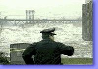
Unlike
most river floods, flash floods happen suddenly. Because they can occur anywhere–from
mountains to deserts–and at any time, they are difficult to predict. They
can be triggered by huge storms dropping a lot of precipitation in a relatively
short time, like when a storm stalls or repeatedly passes over the same area.
In June, 1998, a month’s worth of rain drenched Princeville, Oregon, in
a single day. As a result, the Ochoco Creek quickly overwhelmed its banks and
swept through the town, home to 5,400 people. 400 houses were damaged; others
were destroyed.
 The
ground saturation level can make the situation better or worse; in the latter
case, a flash flood can reach its height in a matter of minutes. In July, 1967,
3,000 people were celebrating the Colorado State centennial in the Thompson
River Canyon, in the Colorado Rocky Mountains. An unexpected 3-hour thunderstorm
poured 12 inches onto the rocky, non-absorbent surface, causing a wall of water
19 feet high to rush along the canyon with enough strength to move boulders
up to 10 feet wide. 139 people were killed and 6 were never found. Many of those
who died were trapped in their cars; signs posted in the canyon today warn visitors
to abandon their vehicles and climb to higher ground at the very first signs
of a flash flood.
The
ground saturation level can make the situation better or worse; in the latter
case, a flash flood can reach its height in a matter of minutes. In July, 1967,
3,000 people were celebrating the Colorado State centennial in the Thompson
River Canyon, in the Colorado Rocky Mountains. An unexpected 3-hour thunderstorm
poured 12 inches onto the rocky, non-absorbent surface, causing a wall of water
19 feet high to rush along the canyon with enough strength to move boulders
up to 10 feet wide. 139 people were killed and 6 were never found. Many of those
who died were trapped in their cars; signs posted in the canyon today warn visitors
to abandon their vehicles and climb to higher ground at the very first signs
of a flash flood.
Dam
failures can also cause flash floods. On May 31, 1889, the South Fork Dam, built
less than half a century earlier about 20 miles upriver from Johnstown, Pennsylvania,
gave way after an overnight rainstorm. A wall of water 70 feet high in places
crashed down the Appalachian Mountains, carrying with it the trees, houses,
rocks, people and animals it had swept up along the way. Floodwaters 23 feet
high and half a mile wide swept over the town, killing 2,209 people in one of
the deadliest flash floods in history.
Coastal
floods also happen quickly, but since they are usually caused by storms such
as hurricanes, they are easier to predict than flash floods. People who live
in coastal flood zones–any place touching an ocean–are used to the
threat of elevated water levels and waves and have prepared accordingly. In
California, seawalls have been built to protect people and their homes as well
as prevent beach erosion. Hurricanes are almost always accompanied by coastal
flooding, as high winds and waves batter shore communities and drag debris out
to sea. In the Eastern U.S., storms in the fall, winter, and early spring–often
called Nor’easters for the rain, wind, and snow they bring from the northeast–are
also notorious triggers for floods along the coasts of states from Florida up
to Maine.
 A
less predictable form of coastal flooding is caused by tsunamis, huge waves
induced by seismic or volcanic activity deep in the ocean, or by meteorites
or nuclear explosions. Tsunamis are as rare but occur most often near Alaska,
Hawaii, and parts of the northwest coast of the U.S.
A
less predictable form of coastal flooding is caused by tsunamis, huge waves
induced by seismic or volcanic activity deep in the ocean, or by meteorites
or nuclear explosions. Tsunamis are as rare but occur most often near Alaska,
Hawaii, and parts of the northwest coast of the U.S.
For
more information on how to be safe in the event of a flood, see the Federal
Emergency Management Agency’s weather site for kids at www.fema.gov/kids,
and the Weather
Channel Safety home page at www.weather.com/safeside.
